Category Archives: Idaho Hot Springs

Hot Spring at Teapot Dome

Teapot Dome HS was another historical soak to have fallen victim of groundwater pumping. It is (/was) located along a tributary of Hot Springs Creek near the base of Teapot Dome just E of Mountain Home. Teapot Dome has been a well-known landmark for travelers as it can be seen from many miles away. The bath house was built in the 1860’s. It was in a popular campground for Oregon Trail travelers at the original site for the city of Mountain Home. Mountain Home was originally known as Rattlesnake Springs and was moved to its present site with the building of the railroad.

N43.15500 W115.51800, 3561′ elev

Warren Crab Feed

If you don’t want to put up with the crowds(?) in McCall, Brundage, or Ponderosa State Park on the first Saturday in March, try the Warren Crab (or Prime Rib) Feed at 2pm.

Warren is about 1 1/2 hour scenic ride up beginning at McCall from the west side of Payette Lake up the Warren Wagon Road. It may take a few hours in the winter depending on your ride. Before you leave the lakeside, you will need to drop your snow rig and leave the car behind.

Going to Warren is always a fun adventure. It is overlooked by most in the winter.

Check out Burgdorf Hot Springs if you want to break up the trip with a short 2 mile diversion over the snow.

Wild and Scenic Lochsa River Corridor

Now they’re cutting the trees way back to allow super huge mega-loads of parts cheaply assembled overseas to make their way to other oil company assets on the other side of the Wild and Scenic River Corridor.

Somehow, that doesn’t seem right. With oil company profits hitting record levels, it does not seem a fair trade to give up some of the value of the area for more oil company profits. It’s not like there are not other options such as doing the assembly in the U.S. with parts brought in on smaller loads travelling other routes which would likely incur less damage.

I sure hope they don’t mess up the river, too. Don’t you?

Bruneau Dunes

Bruneau Dunes State Park is a fantastic place!

It’s pretty hot in the summer and it is impossible to walk the dunes after early morning, but otherwise it is a sure bet good time. They have cabins, sheltered camps in trees and a newer treeless section with electrical and water hookups. They also rent a couple of cabins. The cell phone coverage is good. So, it makes for a great remote headquarters. They take reservations, but I have always been able to find a spot. It is very popular in the spring. The worst(?) we got for an RV spot was a no-hookup spot in the horse camp with a 2-mile walk to the dunes. We made due and actually enjoyed being away from the crowd. I’ll trade a noise crowd for a close up view of a great horned owl an time. Thousands of birds fly in sync in the wetlands.

They have a large telescope and offer a show with night sky and solar viewing Friday and Saturday for a nominal fee. The night sky is generally very dark, which makes for superlative night sky viewing.

Be sure to bring your paddling and/or float craft to enjoy some rays and paddle over to the largest dune. It is a great place to picnic. Dune climbing ranges from easy to very steep. The view from the top is spectacular!

There are plenty of great hiking opportunities including a 7-mile loop around the dunes and along the boundary of the state park. Get a close up view of the Vortex.

You can easily spend several days exploring the area with nearby Owyhee Uplands Scenic Byway, Owyhee Canyon, Bruneau Canyon, Big Jacks, Little Jacks, Three Forks Hot Spring, Indian Bath Hot Spring, Indian Hot Spring, Coyote Hot Spring, Hagerman Fossil Bed, Oregon Trail, Balanced Rock, Cloverleaf Creamery, Box Canyon, Gooding City of Rocks, Zeno Canyon and Shoshone Falls just to name a few! Hicks Springs near Zeno Canyon (N42.50361 W116.06444 5295’ elev ) is a great off-the-grid free alternate site for closer off-road access to the Owyhee Canyon backcountry. Get out your backcountry DeLorme or Benchmark atlas and plan a loop to Murphys Hot Springs and back if you prefer to avoid the tire-ripping backcountry roads and still get a taste of the back roads.

N42.89568 W115.69744 2493’ elev

Lochsa Lodge

The Lochsa Lodge has been on Idaho’s portion of US 12 since it was finished all the way over to Montana back in the 1960’s. The main lodge burned down a little over 10 years ago in an early morning kitchen fire.

The new lodge is really quite beautiful.

It is a short distance off the highway, which should shield you from the noise of the truckers. This is especially important if they are shipping megaloads through through the area. It is a good idea to check first to make sure they are not moving the oversized loads through the area before you vacation in the area as the noise is horrendous and most all of the turnouts along US12 are closed.

At any rate, the cabins are reasonably priced and very pleasant. There is a small general store and a gasoline station on the grounds. It is located right near the eastern access of the Lolo Motorway. There are several hot springs ranging from a commercial spring at Lolo, a popular spring with a short hike, a lesser known natural spring, and a more challenging hike with a potentially dangerous ford to another. The nearby Bernard DeVoto Cedar Grove is a “must see” whether or not you are a history buff.

Meals and views are something that will stay with you for quite some time.

US12 in Idaho is Becoming a Big Load Shipping Route

In order to fully experience the changes the last 80 years has brought about in highway construction, I dropped down to Lewiston from the north via the Old Spiral Highway. Coming from the top and exiting to the right, you see the Snake River. In from the left is the Clearwater River. There are four dams downstream from Lewiston that allows it to be the furthest inland sea port on the west coast. They are the same dams that make it difficult for the once abundant salmon to make it as far upstream as Boise, and Redfish Lake high in the Sawtooth Mountains.

The timing of this trip was such that I would re-experience the trip I made 8 years ago along the Clearwater and Lochsa Rivers to re-trace a portion of the Lewis and Clark route. I had heard in the news of plans to make mega-truck shipments regularly up this scenic byway. I had to see the size of the loads and the road they would travel.

It’s hard to imagine such huge loads travelling up this windy road engineered over 80 years ago.

Surely these loads, taking four days each and blocking both lanes of traffic on their way, would have to take away from this unique experience.

Four loads have been approved to begin tonight, February 1st. 200+ more are in the pipeline. I held off publishing this because I wanted to time it when readers could take some action to voice their concerns at public meetings. That opportunity never came. It has been approved by Idaho’s governor, made it through the courts, and is being allowed to happen. It will save oil companies a lot of money as they will be able to have components made cheaper in Korea and shipped along this scenic highway than the cost of other options. What is the benefit to the locals, recreationists, and Idaho taxpayers? It would seem that that benefit should be approximately what it would cost to provide the components by an alternate method. At least then Idaho could afford to repair damage to the 80+ year old highway and upgrade local infrastructure along the way. How about better drainage, upgraded roadside amenities and fisheries?

Are we going to get it back to the way I recently experienced it or as I remember from 8 years ago? Click here for more information.

Weir Creek Hot Spring

Weir Creek hot spring is the easiest accessible soaker along the US 12 Corridor bordering the Selway-Bitterroot Wilderness. It is not as expansive and crowded as nearby Jerry Johnson hot spring and it doesn’t require a potentially dangerous river ford, as does Stanley hot spring.

The above photo is actually looking down from the spring. The pool itself is a 3-4 person soaker barely waste deep with a log placed across the top.

It is a short hike up Weir Creek from an unmarked parking area on Highway 12. It is a relatively easy hike, but may not be acceptable for people with mobility problems. There are several good dispersed camping sites along the creek.

N46.46333 W115.03500 2880’ elev

Skinnydipper Hot Spring Saved From Fire

The 2010 fire scorched most of the trail to Skinnydipper hot spring.

On September 1, the green light was given for visits back to the spring.

Fire scorched the entire drainage all the way up to the edge of the soaking pools.

However, all PVC pipes allowing precise temperature control, the immediately surrounding plants, and the benches and signs were all saved.

Thanks to the Boise National Forest and the firefighters for saving this valuable resource. This would be the same Boise National Forest that received so much grief from some who felt that they were against hot spring enthusiasts for removing the unauthorized, over-the-top, poorly functioning mortar and paint installed at the Rocky Canyon hot spring. Again, the Boise National Forest has done a great job balancing the needs of a wide variety of public land users!

Wild Rose Hot Spring

Wild Rose also goes by the name Milford Sweat Hot Spring. It is just off the US20/26 near Craters of the Moon National Monument between mile markers 214 and 215. It sits on private land. It is not marked “NO TRESPASSING” or otherwise.

There are two pools. The largest is shown in the photo above. Just out of view to the right is a small deck. Behind that is a smaller pool. The largest pool is nearly 5 feet deep, the smaller is less than 3 feet deep. It is a great place to bring kids for a dip as the water is barely over 100 degrees. On a cool windy day, it may not seem warm enough. The smallest pool is a little warmer. There is no lingering smell when you get out.

While soaking in the pool, you cannot be seen from the highway. It has a history of heavy use and has been found to be totally trashed. That is a real shame because it is really quite nice when it is well cared for. As of the spring of 2010, it is in pretty good shape except for the trail of trash leading up to the pools. Consider yourself lucky if you have it to yourself. If not, use your waiting time to pick up the area, if need be.

N43.36434 W113.78942 4961’ elev

Sawtooth View Hot Spring

Sawtooth View Hot Spring has also been referred to as Snakepit Hot Spring. But, I think you will agree, Sawtooth View is a far more appropriate name.

It is located behind Mountain Village Motel in Stanley just past the decaying pedestrian bridge. Mountain Village (now up for sale – including motel, gas station, store, etc) also has a guest only bath house. However, I don’t see the point in staring at four wooden walls when you have this just a few feet away across the bleached rocks.

N44.22187 W114.93117 6234’ elev

Stanley now has cell phone (no data) service. So you can get caught up here before heading into the backcountry.

Nearby Slate Creek Hot Spring is a must-see and usually provides far more privacy.

Elkhorn Hot Spring

Elkhorn Hot Spring is one of several hot springs along the Idaho Batholith. As you can see, it is located literally right off the highway just out of Stanley along the Salmon River.

N44.24481 W114.88600 6193’ elev

The springs are occupied nearly all the time. The wooden box, sometimes referred to as Boat Box Hot Spring, is generally very hot and needs to be cooled down with a bucket using water from the adjacent Salmon River. It seats two comfortably. Just below, a pool is fashioned with rocks for sitting in a belly-depth pool with water mixing from the river.

It is a convenient novelty for passersby. However, nearby Sawtooth View Hot Spring is far more breathtaking and is usually not occupied.

Oxbow Hot Springs

Oxbow hot springs is an enchanting little place requiring a short paddle between two states and two time zones. Allow an extra hour as you paddle the 1/3 mile across a slack portion of the Snake River behind the Oxbow Dam since you will be losing an hour as you go from the Pacific Time Zone to Mountain Time Zone. Don’t worry; you will make it back on the return trip!

You can park at the first boat ramp south of the Oxbow Dam. There is no overnight parking or camping allowed. There are restrooms at the boat ramp. The mooring on the hot spring side may be a bit tricky along the steep bank. Mooring is slightly easier downstream.

You will find a trail a couple of hundred yards up a slight grade to the trickle of the spring. In the springtime, there is also a cold waterfall to enjoy along Warm Springs Creek. Bring along the binoculars. This is a great place to catch rays while birding and searching the bluffs for pronghorn sheep.

N44.94420 W116.83400 1909’ elev

Arling Hot Spring

Arling hot spring in Long Valley is on private property and is not open for public access.

Buckhorn Hot Springs

Buckhorn hot spring is in prime bear habitat. This is a view up Buckhorn Creek very near to where I encountered the bears. I’d suggest caution in the spring. Make noise while you hike and do not go close to any bear near a food source or cubs.

The trail is nearly 6 miles long and is easily mountain bike-able. It is a constand grade up, but not too bad. It would be a long hike there and back for a day. Just make sure you carry on up the right side of the creek at the second bridge onto the single track, or your adventure may become a lot longer than anticipated.

It is not easy to find. In fact, on my last trip up, I didn’t find it because it is in a fairly narrow canyon. My old GPS did not have a SirF receiver and was giving me intermittant readings. You go all the way up the single track to a sign in front of a large meadow. Then go down to the stream and look for a log crossing over to the spring pool and shower fashioned out of wood and PVC.

I blew off looking real hard for it on my last attempt because I remembered when I did find it before, it was not particularly inviting and I did not want to take the time to clean it, nor did I have the proper gear to do it.

At any rate, I highly recommend this as a mountain bike ride back to a spring followed by a 6 mile coast back to the car. The shower, at least, is worthwhile. The pool, you will probably need to clean.

The Idaho Hot Springs web page has an excellent report on Buckhorn. In it, the author remarks that the stream crossing was dangerous in early spring. It might be a good idea to wait until August or September to access the hot spring.

N44.88542 W115.83873, 5380′ elev

Latty Hot Spring

Latty Hot Spring, off Bennett Mountain Road east of Mountain Home is on private property not offering public access. It is misidentified as Prince Albert Hot Spring in the Benchmark Idaho Atlas. Prince Albert Hot Spring is actually the same as Coyote Hot Spring.

Beardsley Hot Spring

Beardsley hot spring is a commercial establishment B & B called Challis Hot Spring Resort. The resort is also RV and pet friendly.

The run from here up to Missoula is outrageously beautiful! There are lots of Lewis & Clark historical places nearby. Stop here, if you need a commercial break, but as hot spring soaking opportunities go, there are many freebies within an hour or two.

June is a prime bird-watching time at Challis. There is plenty to see with a freshwater pond, rock/talus cliffs and the Salmon River providing a good habitat for birds. You can see Long-billed Curlew, Ring-necked Pheasant, Red-tailed Hawk, Golden Eagle, Osprey and American Dipper. At the gravel pit you can see one of the largest Bank Swallow colonies of the Salmon region. Wild turkeys can be found amongst the Cottonwood trees. Sandpipers are a peckin’ alongside the Salmon. Chukars are like chickens on the loose.

There is plenty of shade, sun, water, and wildlife upon which to feast your eyes!

N44.52250 W114.17361, 4912′ elev.

Bear Valley Hot Spring

Bear Valley hot spring is a first class backcountry soak. Beware of the possibility of red spider mites before disrobing and plunging in! It is about a 3-4 mile hike along Bear Valley Creek from Fir Creek Campground. Fir Creek is a beautiful FREE campground having pit toilets. It is a bit of a bushwack from Fir Creek. So you may want to go upstream to the bridge and take the slightly longer hike on the north side of the stream. The road back is not dusty in the summer as they keep it watered for all the traffic going to the Salmon River float.

It is located near Bruce Meadows, a backcountry airstrip. There is also a cool easy-going 6-mile float trip down Bear Valley Creek from the Bear Valley Campground ending at the Fir Creek Campground. You might need to drag your boat near the end of the trip near the end of the summer. The road is generally snowbound until late June.

N44.44500 W115.23900, 6200′ elev

Vulcan Hot Spring

Vulcan hot spring is south of Warm Lake, BEAR COUNTRY!

I have not been there since the fire. Too bad, it was really a very nice hike. Hopefully, you will be able to enjoy the re-birth of the forest.

In my own experience having been there several times on foot and on MTB (I’m not positive it’s legal, so check for signs), I have found the water to be way too hot and a bit murky. But I’ve read a lot of good trip reports. So, I keep going back. On one visit, we did soak for quite a while but ended up getting some slimy stuff on our bodies that caused welts that lasted for several hours. It itched a bit, but no big thing, we were just somewhat concerned that we may have gotten into something we’d regret. We speculated that it may have been from brushing up against some lily pads.

N44.56722 W115.69500, 5583′ elev

White Licks Hot Springs

White Licks is a great place that I add to both my spring (if snow permits) and fall loops. It fits in nice with the May wildflower tour through Indian Valley, Council Mountain, up over Cascade West Mountain Road. I make the same trip in the fall to see the yellowing of the Larch trees. But, then again, there is really no reason not to make it any time, but it is usually snow-bound Turkey Day through early May. It is a popular snowmobile destination in the winter.

There is camping adjacent to the HS. There are a few HS opportunities. But, the highlight is the high flow into the tub within the shack. This makes fresh water soak free from the goobers that many times build up in other pools. There is also the chance of privacy, even when there are a lot of campers nearby.

White Licks barely escaped the fire in late summer 2007 which went up the Middle Fork of the Weiser River.

The road is in far better early season shape than usual in order to support salvage logging operations

In the spring of 2009, the 1930’s-style bathhouses were in severe disrepair and the tubs had been left with water in them. So, it was quite the yucky mess! There is still plenty of hot water in the area and the flow still seems OK for occasional use. However, in order to use the tub, a few hours of cleaning and scrubbing may be in order. Without restoration, it is doubtful these bathhouses will make it to 2020. They will likely be gone soon.

N44.68151 W116.23000 , 4876’ elev

Council Mountain Hot Springs

Although this soak requires some work when done in early season, and the water is VERY HOT…it is a MUST DO for me every spring. Early May is the primo time to make this trip.

From Boise, take Indian Valley up from Emmett. There is plenty of wildlife and wildflowers to take in.

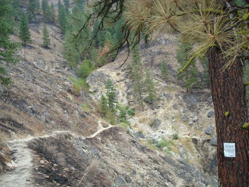
The late summer 2007 fire scorched all the way up the Middle Fork of the Weiser River as well as Council Mountain. Wood salvage operations were beginning again in the Spring of 2009.

A warning is posted for the Council Mountain Trail.

Trees are still toppling and limbs are falling along the trail.

The trail has taken on a new beauty all its own.

The wildflowers are amazing!

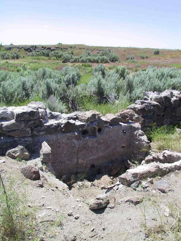
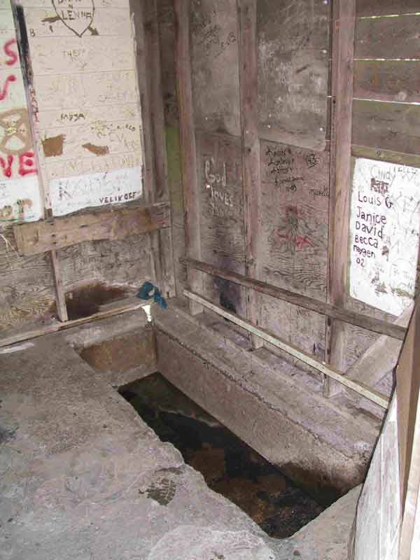
The fire consumed the hot springs. The Forest Service has already replaced the fence around the rather unstable hill.

However, there is still evidence of the pool having been maintained. The runoff inundates it in the springtime.

Later in the summer, it is quite pleasant.

The parking pullout is obvious if you go by GPS and find yourself abreast of the HS. It’s about a 1 ½ mile trek.

N44.66920 W116.30600, 4480′ elev

If snow melt allows, try to hit White Licks, as well.

Also consider mountain biking and bird watching along the 84 mile Weiser River Trail. There are plenty of B & B’s along the way. This is a very nice way to spend a week touring western Idaho while getting exercise and saving on the gas bill. If you take the diversion up the Middle Fork Road to the trailhead for Council Mountain HS, it is about 9-10 miles with an 800 foot climb. It is somewhat exposed to sun near in the valley. But, is cool and shaded along the Weiser River as you make your way up and the traffic is usually light, especially during the week.