Category Archives: Flying

Flying to Canada

My personal checklist:

Aircraft Docs
——————
ARROW – airworthiness certificate, registration, radio station license, operating limitations, weight and balance
Proof of Insurance
Authorized use of aircraft registered to another entity
DTOPS decal U.S. Customs decal

Pilot Docs
————-
Pilot Certificate
Current Medical Certificate
Radio Telephone Operator’s Permit
CANPASS
Passport

Passenger Docs
———————
CANPASS
Passport

Charts
———
Current for type of flight

Pet
—–
Immunization documentation up-to-date

Flight Notifications
—————————
>>> To Canada:
U.S. flight plan (VFR, if able, when active MOA crossing necessary)
1-888-CANPASS 2-48 hrs in advance (ETA, CANPASS arrival point, tail number, full name/DOB/citizenship of each person, destination, length of stay, purpose of visit)
eAPIS 1-24 hrs in advance. Local times for crossing and arrival.
CBP of any high-value items to be declared upon return
CBP and CANPASS of any change
Note: No need to notify CANPASS of arrival if it occurs as planned; park briefly at inspection point to allow awareness for inspection. Report number is valid clearance.

>>> To U.S.:
International flight plan. Foreflight files only IFR. PC required for NavCanada web filing.
eAPIS 1-24 hrs in advance. Local times for crossing and arrival. Record confirmation number for CBP.
CBP 1-24 hrs in advance (ETA, U.S. Customs arrival point, tail number, full name/DOB/citizenship of each person)
CBP of any change
Note: Make sure you meet with CBP upon arrival.

Other considerations
—————————–
No illegal substances, including expired meds
No alcohol into Canada
Expand cell phone coverage or shut off phones and data devices before entering Canada. Info in txts?
Turn off unneeded text notifications before entering Canada
Give Google Voice number for priority voice/texts and plan WiFi comm opportunities
Survival gear required over sparsely populated areas
Some Canadian airports have only approaches requiring DME and/or ADF

Death Valley Wildflowers a Bust in 2012

This would normally the time the wildflowers in Death Valley and other southwest deserts are beginning to bloom. Not so in 2012! This could be the driest spring in a generation for Death Valley.

It is a beautiful area nonetheless. In fact, you can use this year’s apparent lack of life as a backdrop for the Mars & Mojave Festival March 9-10. Come with self-sufficiency in mind if you plan to camp. as the Furnace Creek campground is closed for repairs for much of 2012. There are other camping choices, but you may not get a developed spot.

There are two airstrips in the heart of Death Valley National Park. One at Furnace Creek and one at Stovepipe Wells . But, you will need a bicycle or a thumb to get around more than a few miles a day. You will also need to carry plenty of water. Cover your pitot tube and anything else you want to protect from the fine sand and dust.

Mt Thielsen Lightning Rod of the Cascades

Mt. Thielsen is a highlight for a flight along the spine of the Cascades from Mt. Shasta to Mt. Rainier. It is just north of Crater Lake National Park at N43.15306 W122.06600 , 9182 feet in elevation.

It is relatively accessible by foot. A flyby is perhaps the best way to size it up because it may be wise to stop short of the summit due to the technical nature of the very top. Fortunately, not many try the last 60 foot climb to the summit without roping off as there have been surprisingly few rescues or fatalities over the years. The hike from opposite Diamond Lake up to the junction with Pacific Crest Trail affords nearly continuous closing views of the summit as you emerge from a lodgepole pine forest. It is a fairly (but not ridiculously) steep climb with many rewarding views. If you lose the trail, just continue towards the summit. Circle and approach from the southwest.

When you get to within 200 vertical feet of the summit, you will find yourself scrambling piles of rocks, nearly all of which will move as you scramble over them.

Nearby Umpqua hot springs, Toketee Falls, Watson Falls, Crater Lake, and Natural Bridge of the Rogue, should also be considered to make the drive completely worthwhile.

Ipad Battery Life

8-10 hours! That’s enough for me. SOLD! I’m getting one! I’m tired of being tethered to to an AC outlet. The 2-4 hour out-of-the-box battery life of the typical laptop PC soon becomes just long enough for a quick web surfing session or to keep powered up just long enough to find another outlet.

You can access the web and email, view PDF maps and documents (enough to fly a plane), read ebooks. There are zillions of fun and useful apps, including one to find local pub happy hours! It doesn’t do everything a PC can, but you can bring it along set it down and then pick it up and use it at will.

GPS Jamming By FCC Lightsquared Action

I’m including this link to an article appearing in “Cruising World” mainly because it has a bunch of really good links to some more information about how the FCC is taking action that could very seriously mess up the effectiveness of our global positioning systems. I would otherwise have to include all the separate links myself here. So, even though it does not appear to be a great source, trust me it is.

It has to do with the FCC granting political favors to Lightsquared to make it possible for them to build 40,000 towers emitting high powered signals very near the GPS satellite spectrum. This is all being done to provide 4G wireless connectivity virtually everywhere. Supposedly, the FCC has stipulated that Lighsquared has to make sure it doesn’t interfere with existing equipment.

Let me share something with you based on the decades I spent in the technology field in a former career. You cannot possibly test for the wide range of problems that will crop up whenever you change the fundamental rules under which current technology was developed. GPS signals are in very low wattage. So every GPS device on the market today, as well as those you have already invested in, was tested in this low wattage environment. Now you put high wattage transmitters in the broadcasting bands right next to the ones used for GPS and you have NO IDEA of the problems that it will create. You cannot test for the results of a paradigm shift. Some units may work; some may not, even if they are the same model. Garmin has already run its own independent test on aviation GPS units and have seen some serious problems. Even if fixes are made to resolve THOSE problems, it is unknown whether or not there will be a problem with YOUR UNITs.

I am not an alarmist. That is why I never tune to FOX to be bombarded with their endless NEWS ALERTS. But, I rely on my GPS units for all kinds of orienteering including navigating and landing an airplane in low-visibility or unfamiliar surroundings. This is messed up!

Matanuska Glacier Flyby

Now that the days are becoming noticeably longer with each passing day, I can’t help but think of another one of my top ten flybys – Matanuska Glacier in Alaska. It has a way of reinforcing the “We’ve arrived in Alaska” rush that you don’t really fully appreciate until you get close to the high peaks and glaciers.

Late May or June is probably the best time for this flight if you want to avoid cold weather or the high probability that views may get smoke-obscured with the increasingly common fires in July and August. I can remember a particularly hairy flight when I was unable to land at Northway to clear customs because shifting winds had obscured the runway with smoke. We were allowed to land at Gulkana to fuel before clearing at Anchorage because we became critically low on fuel. Some Gulkana locals told us that the day we arrived was the first clear day they had there in weeks! The Sheep Mountain observation is your best bet for weather when flying the leg between Gulkana and Palmer. If it is socked in, you cannot make it in VFR conditions and you will miss the breathtaking views.

Be prepared for plenty of IFR potential in the late spring. Clouds are no doubt a lot easier on your engine than smoke. Fortunately, when back in the USA from Canada, ATC is a lot more accommodating to pilots wanting to walk the fence between IFR and VFR.

Flying Hells Canyon

Someday, I may go thru my log book and photo collection and attempt to rate my top 10 flights. In the meantime, I’ll just throw them out there as I think of them. It’s difficult to photograph while piloting in awe. So, descriptions of memories will have to suffice on a few.

A recent trip over Hells Canyon in late fall with rising full moon between Pullman (KPUW), Washington, and Nampa (KMAN), Idaho, will most definitely make the cut for top 10 flights.

This photo is taken near the Seven Devils looking towards Missoula at 11,500 feet. Missoula would be one escape route if the weather turned sour southward. On the opposite side would be the Wallowa Mountains being lost in the glare of the sunset. Another route would be to the west on the other side of the Wallowas via Walla Walla, La Grande and Baker City.

The route nearly always has some challenging twists, especially the low clouds that move in and out of the Pullman area. If you can get down to Lewiston under the deck, you can usually break out above the Snake River just before Hells Canyon. I have spent many a low-visibility hours at Pullman waiting for winter fog and low clouds to clear. This would not be a fun place to take on ice! It often lifts around sunset.

McCall Idaho Real Estate, Wow!

If you have access to cash and have a 10-year plus time horizon, you might consider picking up a place in McCall, Idaho. Real estate values have plummeted a good 50% from their highs in 2007. However, the lake is still there, Brundage Mountain is doing well and some time in the future Tamarack may open again, there is fantastic scenery, stream floating, hiking, mountain and road biking, Ponderosa State Park, and easy striking distance to Hells Canyon and Riggins for excitement boating. While you wait patiently for your investment to appreciate, you will be in great place to enjoy!

McCall has a great general aviation airport. Jacob’s Manor, across the highway, has 3BR/2BA bank-owned homes built during the boom from under $100K. There are several other homes for sale within a mile of the airport. Higher-end homes are also available for the choosing.

This is an opportuntity to buy into a very desirable community that does not come often.

Wood River Trail Fly and Bike

The Wood River Trail is one of my favorite fly/bike trips.

If you are an instrument rated pilot, request an instrument approach to Hailey/Friedman Memorial Airport. You will appreciate the separation in a relatively narrow valley from the hot dog locals who often try to outrun you. It is a busy airport and the tower does not have radar. The GPS A is the most common approach. The RNAV (RNP) Y RWY 31 will take you 900 ft lower and has vertical guidance, but will likely require a step down hold if coming in from the Boise. You normally land on 31 and depart on 13. Ride northwest from the airport into town. Right after passing The Mint (100+ year old bar), hang a right on Bullion and left on the trail.

The Wood River Bike Trail follows an easy rails-to-trails gradient that takes you up 600 feet over 13 miles. You ride fairly close to the Wood River with plenty of well-placed rest stops that are well signed with historical information.

The Cold Spring Bridge is one of only 10 remaining Pelgram railroad bridges still in existence.

This is a very pleasant and fairly easy ride. You can add a 10.5 trip on a well-packed dirt road from Ketchum west up Warm Spring Road for a visit to Warfield Hot Spring or head up past Sun Valley up slightly rough Trail Creek Road to catch some spectacular fall colors if you want more of a challenge or perhaps turn it into a weekend trip.

Driggs

September and October is the best time to do some recon in Driggs for your winter trip to Grand Targhee Resort. The leaves are changing, there is a cool snap in the evening air, and there are very few tourists to compete with for the best places to stay.

If you fly in, give your autopilot or your manual skills a shake out by flying the RNAV (GPS) RWY 03 approach into Driggs to see if you catch all the turns! If you drive, check out the Teton Dam site on the way in. Teton dam was the last really big dam built in the United States. It failed.

Prices in Driggs are a bit steeper than one would expect for a sleepy town in the off-season, although you can get some great off-season deals between Driggs and Grand Targhee. Don’t bother making reservations if you go in September or October. Being a pilot, we always check on cancellation policies in case the weather turns bad. Most places required 48 hours, some as long as a week. When we arrived in early October, we found most places were empty.

Hike the back side of the Grand Tetons from the Alaska Basin area. Take Alta Road northeast of town and hang right at FR009. Take it all the way to the end and hike! If you don’t come prepared to hike a long way, you will wish you did.

Resist the temptation to hike anywhere much further north than Grand Targhee resort. It is over-grazed, trampled, and unsightly. We’ve hiked up Tin Cup Creek and had we not done the Alaskan Basin later we would have left with a negative impression of the entire area. Believe me, you will quickly learn why grazing cannot be mixed with land used for hiking and solitude.

From Driggs, you will be within easy striking distance of Jackson. If you are a red meat fan, check out Bubba’s on the west end of town. They don’t have a liquor license, but will let you carry in your own growler or bottle of wine you can pick up across the street. The Cowboy Bar is also worth a peek.

Driggs is also a fabulous destination in busy times. There are some great fishing spots, fun floats and easy bike rides with fantastic views of the Tetons. Grand Targhee Resort generally has great snow with some really fabulous early season deals.

Watson Lake in the Yukon

Airport Bed and Breakfast is one of the best places to stay en route between the Lower 48 and Alaska. It caters particularly to pilots. They bend over backwards, believe me.

This photo was taken a few years ago when Rob and Debra Hadwen use to run it, but it is essentially unchanged. It has 3 bedrooms in the Bed and Breakfast area of the home. It is a nice setup for those who don’t want constant interaction with the innkeeper. Kitchen, TV and high speed internet access give it modern appeal in a historic setting. This place was originally a church.

Lelah works in town. So, breakfast is no longer served as it was in the past. She sets it up for you. She currently has it up for sale so that she can move south. Gord & Cindy Sundby’s Cozy Nest would be a good alternate.

Whether you are driving the Alcan Highway or flying the trench, when you cross the border from British Columbia into the Yukon at Watson Lake Watson Lake, you’ll know you are getting really far north! For being seemingly out in the middle of nowhere, the people are surprisingly hip. Our sweetheart waitress in town could have been scooped up and transplanted from New York City. She is the real deal with her jet black dyed hair, tatts, and piercings. The semi-permanent arts and craft mart has some true originals.

Bring a sign for your hometown to add to the nearby sign forest.

Northern Companion Aircraft Pre-heater

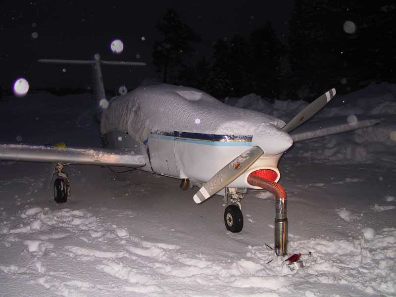
On my first Alaska trip, some locals in Gulkana turned me on to the Northern Companion. It weighs only 6 lbs, burns just about any kind of gas (I use white gas), and heats up my Piper Lance from stone cold to around 50F in 45 to 90 minutes – about the same time it takes to load, preflight, and clean the surfaces of snow and frost. It collapses into a very small package and only requires the same amount of gas as a backpacking cooking stove (one of its component parts).

I have ever since been a 4-season pilot without the concerns of the excessive wear caused by starting the airplane with gooey oil. It doubles as a camp stove when I camp by the plane.

Hobo Hot Pool in Saratoga

Hobo Hot Pool is a bit off the beaten path (20 miles) for through drivers on I-80 in southern WY. It is, however a great stopover for those doing the national park tour (Jackson Hole/Yellowstone and Rocky Mountain NP), taking the motorcycle route, or private pilots looking for a fuel stop (KSAA). It is roughly halfway between Boise and Minneapolis or between Salt Lake City and Chicago. It is a good place to land and wait for summer TSTRMS to clear before making the turn at Elk Mountain to descend into Boulder/Denver area or back across the expanse of southern WY. If you are driving/riding out Yellowstone on the east side on US 20, you might also consider a stop at Thermopolis.

Everything in Saratoga is an easy walk from the airport, including Hobo Hot Pool. It is a couple of blocks off Main Street (SR 130).

The pool is quite hot. It runs on donations.

N41.45000 W106.80400 6797′ elev