Category Archives: Oregon Hot Springs

Mt Thielsen Lightning Rod of the Cascades

Mt. Thielsen is a highlight for a flight along the spine of the Cascades from Mt. Shasta to Mt. Rainier. It is just north of Crater Lake National Park at N43.15306 W122.06600 , 9182 feet in elevation.

It is relatively accessible by foot. A flyby is perhaps the best way to size it up because it may be wise to stop short of the summit due to the technical nature of the very top. Fortunately, not many try the last 60 foot climb to the summit without roping off as there have been surprisingly few rescues or fatalities over the years. The hike from opposite Diamond Lake up to the junction with Pacific Crest Trail affords nearly continuous closing views of the summit as you emerge from a lodgepole pine forest. It is a fairly (but not ridiculously) steep climb with many rewarding views. If you lose the trail, just continue towards the summit. Circle and approach from the southwest.

When you get to within 200 vertical feet of the summit, you will find yourself scrambling piles of rocks, nearly all of which will move as you scramble over them.

Nearby Umpqua hot springs, Toketee Falls, Watson Falls, Crater Lake, and Natural Bridge of the Rogue, should also be considered to make the drive completely worthwhile.

Best Fall Colors in SE Oregon

The best fall colors in southeast Oregon are seen along Oregon Canyon Road ( N42.21370 W117.77200 4768′ elev ) and Arizona Creek Road in the Pueblo Mountains ( N42.14471 W118.60376 4190′ elev ).

In between, you can soak and camp at Willow Creek hot springs.

Easy access onto dirt roads from main highways or some very hair-razing back country roads cross country point to point! Arizona Creek Road can get kinda hairy after the first couple of miles. It is a good idea to bring a mountain bike to get to the source of the vistas that beckon. Wildhorse Ranch Road, by comparison, is like a freeway as gravel roads go.

Bingham Hot Spring

Bingham hot springs is on the Bar M (dude) Ranch. It is in NE Oregon near the Stateline wind farm (which supplies Pasco, WA with 20% of its electricity).

N45.74100 W118.23300, 2189′ elev

Barry Ranch Hot Spring

Barry Ranch hot spring is on private property just south of Lakeview with no soaking opportunities. There are some test wells left over after a geology study by The Oregon Department of Geology and Mineral Industries.

Canters Hot Spring (historical)

Canters HS on the west end of Jordan Valley made its last entry into a geothermal survey in 1967. That was about the same time ranchers and farmers began deep water pumping from the aquifer. It has long since been dry. The last sign of hot water under Jordan Valley disappeared a few years ago.

Groundwater pumping in SE Oregon and SW Idaho makes rather wide cones of depression. Underneath, there is plenty of hot rocks. Hence, the remaining springs in the area are found near surface water.

Willow Creek hot spring is one notable exception. However, even when viewing the surrounding area by air, you will see that Willow Creek is a tiny remnant of a much wider geothermal area that surrounded it in relatively recent times. Alvord hot springs gets plenty aquifer recharge from Steens Mountain runoff and there is little nearby groundwater pumping.

N42.97700 W117.06100, 4400 ft elev

McCredie Hot Spring

You should plan on spending some time socializing when you go to McCredie. It is literally right off the highway just up the hill from Oakridge. It has a large dirt parking pull off and is very popular amongst truckers and whoever else might be driving by. It is signed. So it is pretty hard to miss it.

There are usually several rock pools, the biggest being 20-30 feet across. They are about 2 feet deep and can be quite soothing. Mornings are really nice since the spring is frequently veiled in a light wispy fog.

If you are coming up from the valley, you might consider going up the hill about 12 more miles and spending a few hours hiking around Salt Creek Falls.

N43.70417 W122.28611, 2000′ elev

Summer Lake Hot Springs

Summer Lake Hot Springs is a commercial establishment.

It is in one of the best birding areas of Eastern Oregon, including the threatened Snowy Plover. It is a fantastically beautiful area roughly halfway between Hart Mountain and Paulina Lake. It is on the route from Reno to Bend (if you think in terms of cities). It is along the route referred to as the Oregon Outback Scenic Byway.

The character of the area may change dramatically if a proposed nearby hydro-project moves forward.

N42.72500 W120.64600, 4271′ elev

Luce Hot Springs

It is a spectacular drive down Juntura Riverside Road (start from the behind the Juntura schoolhouse). We got close up views of Pronghorn Antelope and Bighorn Sheep near Juniper Canyon.

There are plenty of hot water seeps to be found on a cold morning. However, the private landowner and surrounding neighbors make it clear that they do not want you trespassing in search of Luce HS. Nearby Juntura hot spring (undeveloped, natural) and Crane hot spring (commercial with camping and cabins) are good alternates. Leave this stretch for viewing scenery between Juntura and Crane and respect PRIVATE PROPERTY.

There is a good BLM spot with toilet and tables looking up Juniper Canyon and the Malheur River near the historic Riverside settlement.

Umpqua Hot Springs

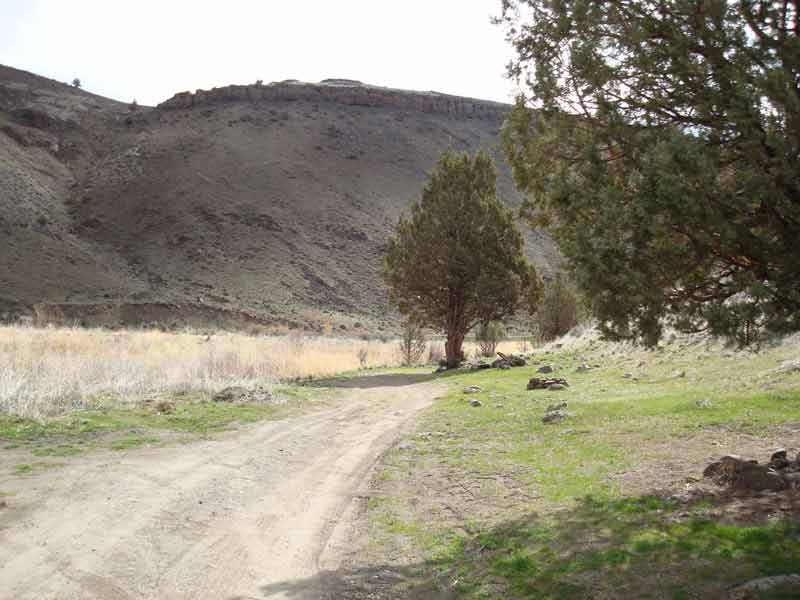
Umpqua hot springs are accessible year-round, except it can be slow going and somewhat tricky in the winter when the trail is packed with ice. When the snow is really deep, it may be better to follow the shorter route over the bridge along the road to the recreation site. In the winter of 2008-2009, a boulder was placed on the far side of the bridge to restrict wheeled access. The foot bridge back over the river from the recreation site was still missing as of the spring of 2009. A log crossing with an attached board has been fashioned, but that may pose some risks when it is slippery and the river is raging. A safer and more scenic route is along the North Umpqua Trail through the forest. It is south facing and melts sooner in the spring than the road. It is also a great mountain biking route. You can also take a short hike down from Upper Mountain Meadow once the snow has melted to allow access. The area is right at the winter snow line. So, the winter access will depend on how recent cold storms have moved through the area. You should be able to get current information by contacting the Toketee Falls Ranger Station for the Umpqua National Forest.

The hot springs are popular and well-maintained. You can have it to yourself on most off-season weekdays, but expect to find other people enjoying the springs. Wayne, one of the people who routinely clean the pools, can be a bit nosey. But if you don’t want to share your name and life story, make it up! He’s usually gone in the summer. It is posted clothing-optional.

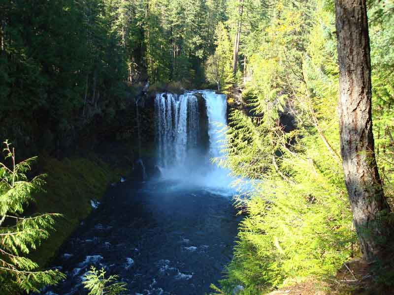
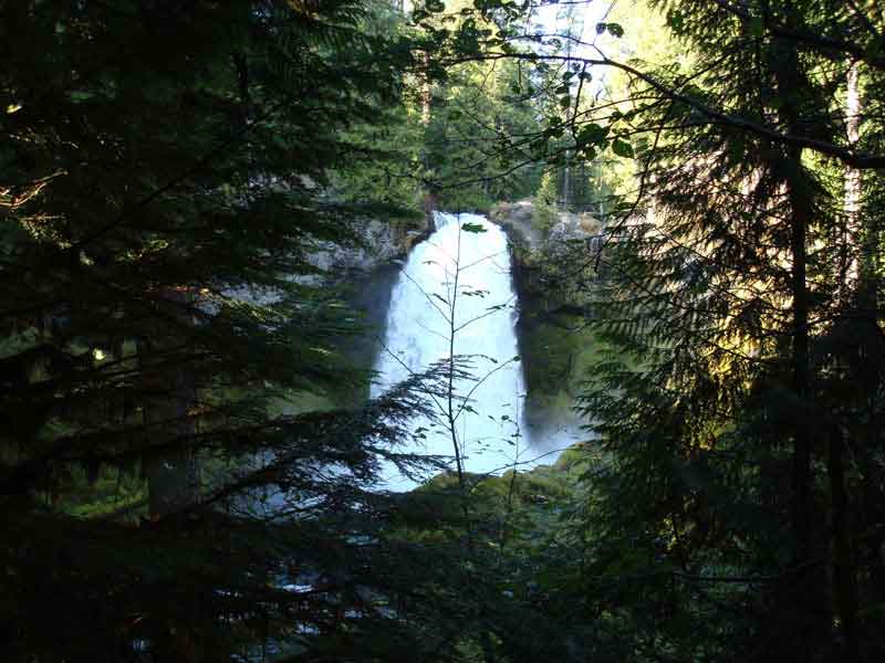
Check out nearby Toketee Falls and Watson Falls. After a severe winter storm in December 2008, the trail to Toketee Falls was closed and remained closed into 2009 until repairs can be made to make the trail safe again. Nearby Toketeee Falls Campground is open year-round and generally has sites available except possibly during summer weekends. There are some great sites with a few along the water, but no drinking water. It gets 4 bars of Verizon cellular covereage. So, it is a prime remote office location! There is plenty of other nearby camping in the summer. Although, it may be somewhat busy during the weekends and holidays. Nearby Diamond Lake is good fishing again after it was intentionally poisoned to remove invasive species and then re-stocked in 2006. Nearby Mt. Thielson (the lightning rod of the cascades) is easily and breathtakingly hike-able up until the last 1/2 mile of loose boulders and the last 60′ which should be a done while roped. There are also a lot of good hiking and mountain biking opportunities nearby Crater Lake National Park. So, why not take a couple of days off and check it out!

Watson Falls is a few miles up the road from Toketee Falls turnoff.

You can see the shelter at Umpqua hot springs just slightly off the North Umpqua Trail.

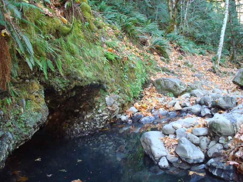
The hottest and clearest pool is behind the shelter and is about 108F.

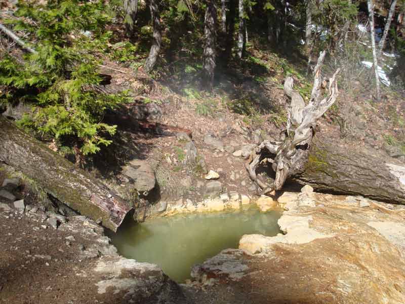
The shelter is fairly pleasant. I think it would feel like you are soaking in someone else’s bath during a busy season as it is not real hot and the flow is very slow. Fortunately, we had it to ourselves on a nice sunny day and enjoyed the deck on our own.

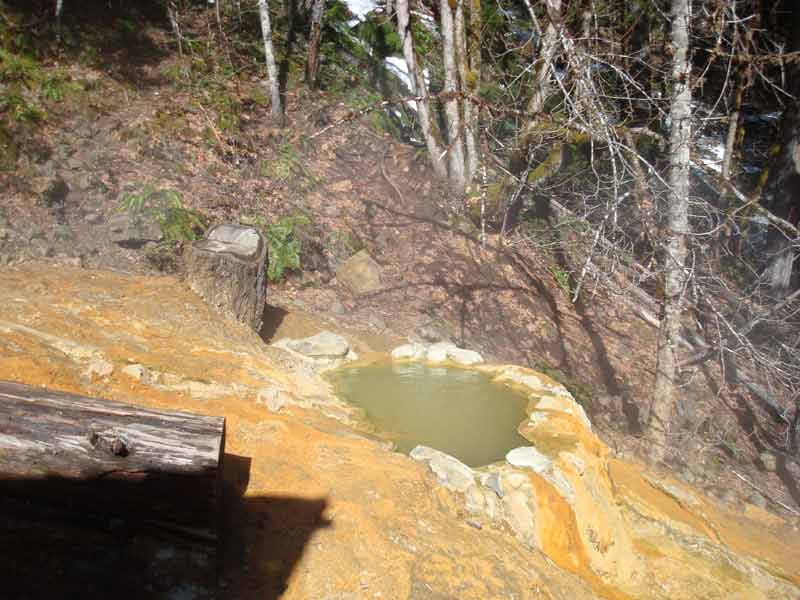
The pool on the side of the shelter is a nice spot to catch some sun, but perhaps a bit cool otherwise.

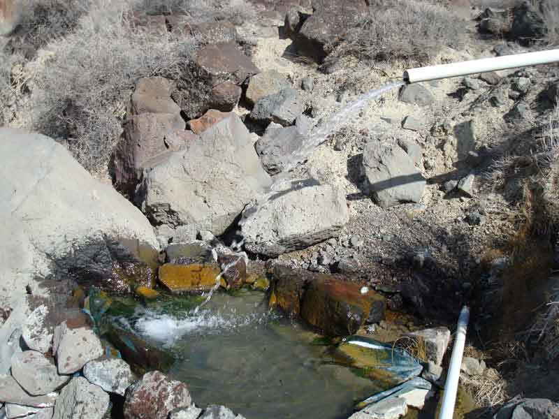
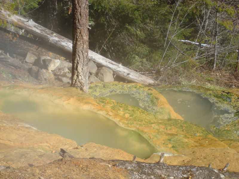
Tell Wayne he needs to do a better job keeping the lower pools clean!

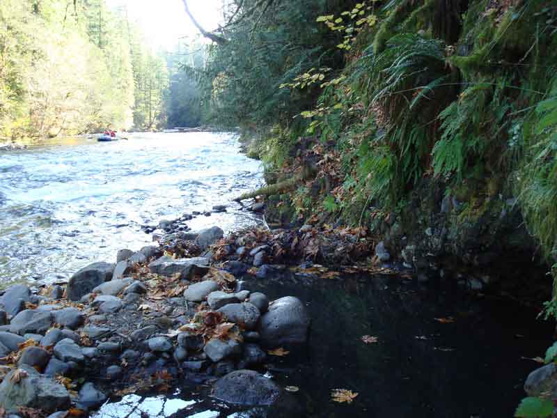
N43.29400 W122.36700, 2631′ elev

Crump Geyser

The Crump Geyser is near the town of Adel and Hart Mountain. No, it’s not a soaking location. But, it does have some interesting potential for geothermal power generation.

N42.22600 W119.88100, 4507′ elev

Echo Rock Hot Spring

Echo Rock Hot Spring is also referred to as Owyhee Hot Spring. N43.30186 W117.38461 , 2718’

The turnoff from US 95 to McBride Road may be closed by Owyhee County in the spring to avoid rutting. If it is, an alternate route up Succor Creek Road in Oregon can be used several miles to the south.

Reaching over 4700 feet, it can be a bit tricky with snow.

Here we are driving down into Leslie Gulch.

You can see from this picture taken from the boat ramp that the window of opportunity is starting to close as the river is rising and covering some of the road beginning with the spring run-off. Once the road is submerged, it can be reached by paddling upstream about 4 miles.

So, it’s up on the bank for several hundred yards.

After the first 1 1/2 miles by land, it is easy going. The water in the lower pool is a bit tepid and murky for my liking. But, the shower is nice. One can lay down for a soak or two can share an intimate bath.

The view from the upper pools is breathtaking.

The upper pools were recently re-done with mortar. They may become contaminated with cow dung, as open grazing takes place nearby. But, they can be easily emptied and refilled. The water is quite hot after a refill and may require 30 minutes or so to become comfortable. Note the difference in water level. This photo was taken on a different trip later during the summer.

The trip back was equally impressive! Not a soul to be seen mid-week spring days, a great time to work on the year’s first all-over tan.

This is, indeed a great experience! This shoreline route is only accessible late fall to early spring when it is not snow bound. This is the third of the three you pass if you run the Owyhee from Rome to Leslie Gulch. Upstream is quite a bit more challenging when it’s running. You can also rent a pontoon from Indian Creek in the summer and make it back. There are two nearby areas of interest to rock hounds. One is a legal place to collect petrified wood; the other is up Succor Creek through Thunder Eggs. I have personally never found a geode there of any value. Both rock hound areas are WAY TOO MUDDY until the summer.

Wall Creek Hot Spring

Wall Creek HS is also known as Meditation Pool. The springs themselves are murky and tepid. However, the surrounding area is quite nice. It is in an old growth forest just outside Oakridge, OR. Take First Street E out of town. It becomes Salmon Creek Road. Turn left on Forest Road 1934 and park about 1/2 mile up to trailhead. It is a short easy hike…highly recommended on a hot day.

N43.80800 W122.30900, 2341′ elev

Terwilliger Hot Springs

Terwilliger Hot Springs is also called Cougar Hot Springs. For conditions, try the Friends of Cougar web site.

It is a VERY nice setting in an old growth forest with a spectacular view of a waterfall.

During winter and spring runoff, the pools can be quite tepid. Otherwise, the pools are perfect temps. CO is the norm.

With all that said, I must add that the $5 PER PERSON fee to a private concessionaire to hike a trail in a National Forest is outrageous. $20 for a carload of 4, $30 for 6!

The fee is supposedly to insure safety of your valuables in your vehicle, pickup and maintenance of the trail and pools; you know, the stuff you would hope would happen in a National Forest anyway, especially if you paid already for a NW Forest Pass or Golden Eagle Pass. Why they don’t provide free hookup and space for a volunteer caretaker, I don’t know. Why not $5/VEHICLE? I just have a real hard time promoting the privatization of public land, especially at such an exorbitant (“don’t go if you’re poor”) rate.

Oh, and don’t bring drugs. Even though law enforcement cannot be provided to ensure vehicle safety, they are said to bring drug sniffing dogs so that they can pop you for unprescribed medicines when you return.

With that said, I highly recommend doing the Aufderheide National Scenic Byway, which is part of the West Cascade Scenic Byway. Start off at Terwilliger so that you can arrive before the fee collectors. The route is especially nice in the October to catch the fall colors. Before you pop out the Southern end, a walk around Constitution Grove ( N44.88230 W122.11790 , 2767’ ) is breathtaking. Also, you will see Office Bridge, a good example of the many covered bridges in Oregon, at Westfir.

Terwilliger is at: 44.08361 W122.23806 , 1800′ elev

Deer Butte Hot Spring

Deer Butte HS is a little hot trickle on the side of the road on the way to Snively hot spring and the Owyhee Reservoir. You can use it to wash your feet. I climbed up on the rocks above that appeared to have a bowl carved out by water that would make a great soaking pool. No go. Maybe it was some day a while back. I’ve checked it out in a couple of seasons, but still looks to be a bust.

N43.73900 W117.17800 , 2387′ elev

Lucky Seven Hot Springs

Although known by locals as Lucky Seven Ranch Hot Springs, it is referred to as Easterday Hot Springs in some guide books. It is a nice diversion at short distance off US 95 in SE Oregon. The water temp is 100+ or -. There is a stream and many seeps you can put a hose into to fill up a tub. There are great views of the mountains from the springs. It is located within a wide area of HS activity. The road in is somewhat rutty and can get pretty muddy in the spring. I’m sure the ranchers would appreciate you not leaving deep ruts in the road. There are quite a few alternate routes available that are a little higher on the ridge. Water clarity is OK. It is a little murky if you stir it up.

You can gamble, eat, or buy supplies just across the border in McDermitt, NV.

N42.07672 W117.76000, 4465′ elev

Snively Hot Spring

Check it out. I have never thought this was worth a special drive. But, I have heard it can be pretty nice. I suggest doing it before irrigation season starts, since releases from the Owyhee Dam can make it submerged. It is also submerged with a heavy spring runoff as it was in 2006. You can regulate the temperature by moving closer to the source or out to the river to cool it off. It is very popular with local youths. Due to its nighttime popularity for parties, it has recently been closed at night. You may still find it in trashed condition. It is close to the highway and is marked with signs. The pools are quite shallow and need to be reconstructed after flooding.

Owyhee Reservoir and environs are quite nice. You can boat back to Echo Rock HS form the south end of the reservoir. Other nearby HS do not offer soaking opportunities. There are two very pleasant campgrounds along the Owyhee Reservoir. Pontoon rentals and weekend music make this a very fun place. So, a stop at Snively is a nice break while traveling to or from the reservoir.

Now a look at it during high-water (Spring 2006)

Of course, that was going on during the Big Suck up above at the Owyhee Dam. This occurrence brings lots of observers in the spring.

N43.72986 W117.20336, 2265′ elev

Antelope Hot Springs

This is a shot of what I consider to be one of the most beautiful places on Earth. It’s looking over Warner Valley on way up to the Hart Mountain.

The hot springs are sometimes referred to as Hart Mountain Hot Springs because of its location on the Hart Mountain National Antelope Refuge. This is a must-see place which is accessible pretty much all year long, except after heavy snowstorms. Plan a stop here if you are travelling between Boise and Reno, northern California or south-central Oregon. It is an easy up and back from Warner Valley, or you can drive the washboard road north to Frenchglen. 4WD, hike or mountain bike to the remote areas of the refuge for unbeatable vistas and abundant wildlife viewing. Anthropologists will also find signs of past cultures.

There is a stone structure providing privacy and shelter from the wind around the pool. Note the sign telling you not to bring soap.

There is also a more natural soaking pool several yards upstream.

ONDA’s 2009 Sage Grouse Lek Monitoring is April 23-26. If you would like to volunteer to monitor leks on a different date, or would like to stay longer, the refuge needs volunteers from March 17 to May 4. For more information regarding volunteering on different dates contact Marla at the Refuge: marla_bennett@fws.gov

This is a great activity as an excuse to visit the hot spring. There is nothing like seeing the Sage Grouse dance at daybreak!

The 2009 ONDA Hart Mountain fence pull is July 24-28. You can stay at the dorm or camp by the hot springs.

Jonesboro Hot Spring

Jonesboro HS is a warm shower cascading down from a hill to the side of highway US20 east of Juntura. A few years ago, I took an early morning shower here. The house next door is posted no trespassing. I guess they are probably tired of visitors.

N43.79500 W117.95800 2861′ elev

Bigelow Hot Spring

Bigelow is a short walk downstream after crossing the bridge on a dirt road off US 20. It may be wet and muddy during high water. It is a good stop on a float trip down the river. The water is tepid to warm, although you can move to an area in the cave where it is coming out quite hot.

It is also referred to as for Deer Creek Hot Spring. Sohalie Falls

N44.24100 W122.05800, 2014′ elev

Sohalie Falls and Koosah Falls are also worth seeing while you’re in the area.

Horseshoe Bend Hot Spring

Horseshoe Bend Hot Spring is also commonly referred to as Juntura Hot spring. The USGS lists 3 hot/warm springs in the Juntura area. The spring listed at N43.75800 W118.06700 2999′ elev is a seep on a hill just north of a dirt road that follows the North Fork of the Malheur River just off US20. The spring listed at N43.75700 W118.09200 2951′ elev. is behind a fence on private property along the North Fork of the Malheur River. When surveyed nearly 20 years ago it had a 95F temperature. It is not suitable for soaking.

The Warm Spring at N43.77603 W118.04771 2926′ elev is the soakable Horseshoe Bend Hot Spring. It is commonly identified as a nude soaking location. It is located along the Horseshoe Bend of the Malheur River leading into Juniper Gulch and can be accessed via dirt road just NE of the new Horseshoe Bend Bridge over the Malheur River. The road is rough, but travelable for most vehicles. It gets pretty rutty after it rains or snows. The last 1/2 to 1/4 mile will put significantly more wear and tear on your vehicle as it is frequently flooded in the spring. It has quite a bit of river rock you have to travel over to reach what becomes an island in high water. The pool is about 100-104F in a setting that is quite nice. There are plenty of disbursed camping in the nearby area and you will usually find someone camping in the area. This is the site of numerous parties, but is generally in good condition. There is a memorial at the pools edge where an unfortunate fellow drowned a few years back. Remember, it is best not to drink and soak unless you bring someone along who is capable of fishing you out should you pass out. Although the setting is nice, it is really not the highlight of a spectacular canyon you travel along US20 between Boise and Bend. There is a free RV dump at the rest stop 18 miles W of Burns.

This picture was taken from the hill overlooking the pool from the NW. It was taken from the road on the opposite side of the river. You would need to get through a fence to approach from the high road.

The channel has water and needs to be waded. I suppose you could 4WD right through it, as some have. But, keep in mind, you will only be tearing up the island and stirring up dirt in the Malheur River.

The 2006 fire burned much of the adjacent area to the NW and a bit to the S. Fortunately, there are a couple of nice shade trees making for a nice camp that remains.

The old bridge one is still passable. You can approach from either side. The road to the HS is < 1 mile. It’s the one on the right or E side of the bridge.